The Riparian Condition Assessment (RCA) tool models the condition of riparian areas based on four components: riparian vegetation, land use intensity, floodplain connectivity, and overall vegetated area. Each reach of an input network is attributed with values on continuous scales for each of these components. The output condition of each reach is then assessed using a fuzzy inference system. The tool produces an output polyline shapefile as well as an output table which can be joined to the polyline using the “RCH_FID” field.
Parameters
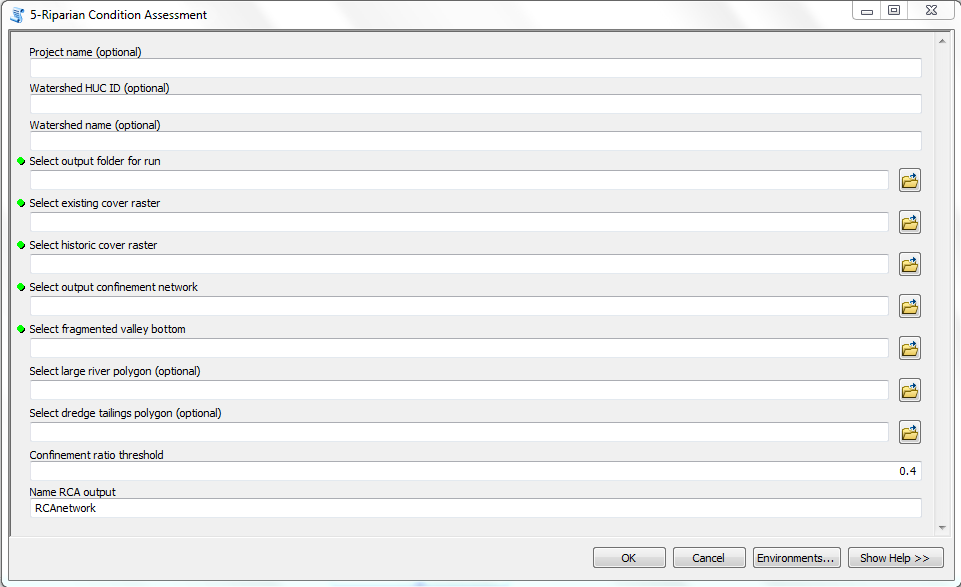
- Project Name (optional): Project name to be used in the XML metadata file.
- Watershed HUC ID (optional): Watershed HUC ID to be used in the XML metadata file.
- Watershed Name (optional): Watershed name to be used in the XML metadata file.
- Select output folder for run: Select output folder for run (format Output_01).
- Select existing cover raster: Select the existing vegetation layer from the inputs folder within the project folder.
- Select historic cover raster: Select the historic vegetation layer from the inputs folder within the project folder.
- Select confinement network: Select the stream network shapefile from the inputs folder within the project folder.
NOTE: In the current version of the tool, if the stream network contains too many features (or segments), the tool will run out of memory and fail to run. Stream networks for watersheds can be clipped down to subwatersheds to run the tool with, and then the outputs can be merged together. For future versions, this issue will be resolved.
- Select fragmented valley bottom: Select the valley bottom shapefile from the inputs folder within the project folder.
- Select large river polygon (optional): Select the large river shapefile from the inputs folder. In areas with large rivers (ie Green, Colorado, Snake, Columbia), all landcover cells within these large river polygons are coded as no data. In smaller rivers, the open water landcover class is coded as riparian. In development, we found that coding open water in large rivers as riparian skewed them to appear to be in better condition than they are. In small rivers, if open water was not coded as riparian, they appeared to be in worse condition than they were. The “Area” shapefile that was downloaded with NHD data can generally be used as this large river polygon.
- Select dredge tailings polygon (optional): Select dredge tailings shapefile from the inputs folder. In areas with dredge tailings, existing riparian landcover is coded with a vegetation score of “0” - i.e., no riparian vegetation.
- Confinement ratio threshold: Enter a confinement ratio value above which streams will be considered “confined” and below which the streams will be considered “unconfined.” The default value is 0.4.
NOTE: The default threshold is 0.4. Decreasing this value will result in more confined reaches, and increasing the value will result in fewer confined reaches. Prior to running the RCA tool, the confinement tool output can be investigated and visually compared to imagery to determine an appropriate threshold.
- Name RCA Output: Specify name for the final polyline output which will be saved in the outputs folder within the project folder.
Outputs
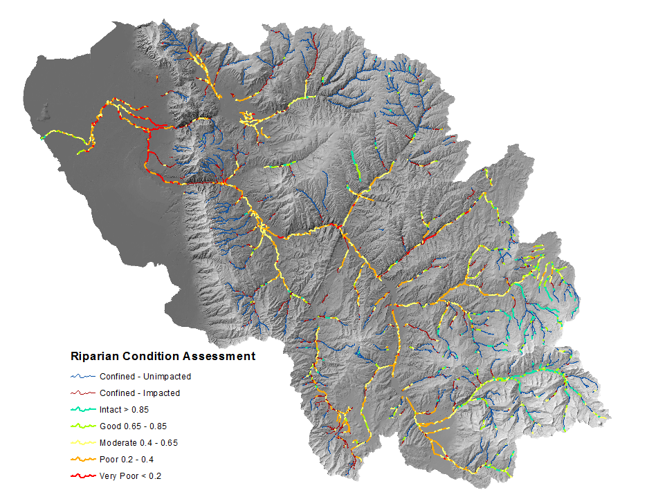
RCA Network
The RCA output symbolized using the default symbology of the CONDITION field.
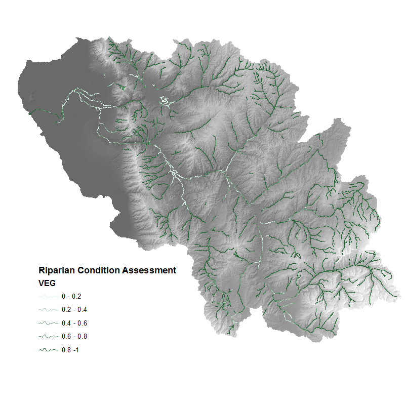
Additionally the VEG field may be of interest, and simply represents the proportion of historic vegetation cover (riparian and non-riparian) that exists on the landscape today.
The RCA output symbolized using the VEG field to show the proportion of historic vegetation cover that exists now.
Additional RCA Output Fields
RVD: The riparian vegetation departure score (proportion of historic riparian vegetation) for the given stream segment. LUI: The Land Use Intensity index, on a scale from 0 (high) to 3 (low). CONNECT: The proportion of the polygon (floodplain) associated with stream segment that is accessible to the stream. COND_VAL: A value on a continuous index from 0 to 1 that represents the condition of the riparian area for unconfined streams. (a value of 0 means that the stream is confined and the value is not relevant.)
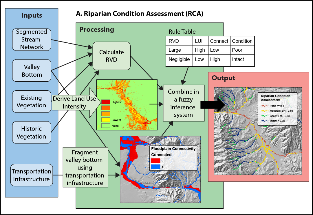
Conceptual diagram showing how riparian condition assessment is calculated